Concept
Alternate Profiles
Different views and formats:
Alternate Profiles ?Profiles (alternative information views) encoded in various Media Types (HTML, text, RDF, JSON etc.) are available for this resource.
- Preferred Labelskos:prefLabel
MD208e
- URI
- https://standards.isotc211.org/19157/-3/1/dqc/content/measureDescription/MD208e ↗Go to the persistent identifier link
- Within Vocab
- ISO19157-3 quality measures
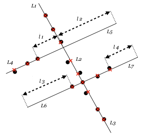
| Definitionskos:definition | Calculate the rate of omission of street view imagery (SVI) coverage using street network as the reference data. In the example, street view imagery is represented as points (circular dots in the figure), and the reference street network consists of seven line features of length L1, L2, … L7. Step 1: Snap each point to the nearest location on the street it is closest to. Snapped locations are marked by red crosses in the figure. Step 2: Split the lines at the snapped locations and calculate the length of each split segment. Segments with a length longer than a certain threshold (e.g. 50 m) where no SVI is found are deemed as uncovered. In this example, we identify four segments with lengths l 1, l 2, l 3, and l 4 as uncovered segments. Step 3: Rate of omission is thus calculated as the sum of lengths of uncovered segments, divided by the sum of lengths of all segments. The example demonstrates a way to calculate the omission rate for the whole dataset. Besides, the omission rate can also be calculated at a finer spatial scale, i.e. for each geometry unit. For instance, it can be calculated at the street level, where the omission rate is calculated for each street segment. |
|---|---|
| has broaderbroader | 208 - rate of omission for spatial coverage Percentage of reference feature geometry where data is absent. |
| notationnotation | MD208e |
| http://xmlns.com/foaf/0.1/depictiondepiction |

|
